(ATF) The China State Council’s policy briefing on Monday July 13 stressed that China is about to enter a critical period of flood control in the “seventh and eighth” category, regarded as a super alarm.
The current flood situation in the Yangtze River and Taihu Basin is grim. It is expected that rain will fall in the north in coming days and that large regional floods may occur in northern rivers.
It is speculation at present to calculate the economic cost, but by comparison this flood is said to be far worse than the flood ranked as the world’s second biggest in history – the flood in July-August of 1998, which led to 4,000-plus deaths and an economic loss of US$43.7 billion.
It can only be surmised that the cost of this flood may be well over $100 billion.
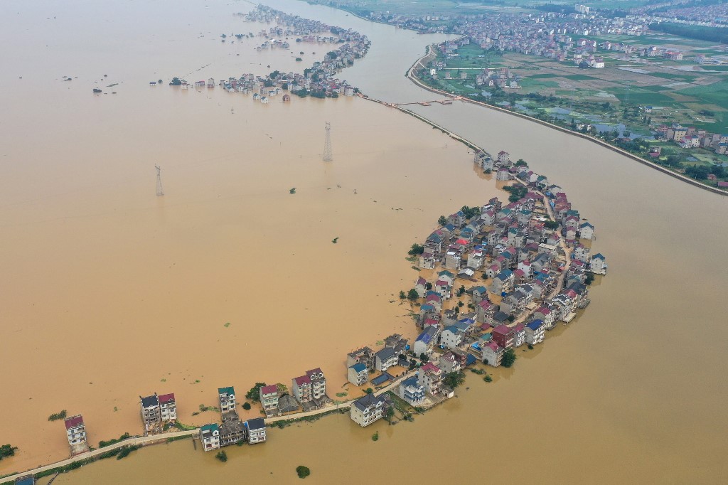
Ye Jianchun, deputy minister of water resources, told the State Council briefing that heavy rain and floods have occurred frequently in southern China since June, with severe disasters in some areas. There were 433 rivers with overflow-alarm floods in the country, including 109 rivers that breached flood barriers, and 33 rivers at historic levels.
The Yangtze River, the upper reaches of the Yellow River, the Xijiang and Beijiang Rivers of the Pearl River Basin, and Taihu Lake have all flood in succession. At present, the water level below the Jianli River and the Dongting Lake, Poyang Lake and Taihu Lake are still at “super-alarm status.”
Other rivers have more stable water conditions. But flooding tends to come in waves. In some areas there is a bit of a lull, with more flooding expected in already flooded areas as well as different places.
Ye Jianchun emphasised that China is about to enter a critical period of flood control.
This year China has a large total rainfall and with localised intensity, according to Zheng Guoguang, secretary general of the National Disaster Reduction Committee and deputy director of the Emergency Management Department. The average rainfall in the Yangtze River Basin since June is the second highest since 1961 with many provinces flooded.
Nearly 28 million disasters had been declared in 27 provinces, autonomous regions and municipalities across the country. Some 141 people were missing and 28,000 houses had collapsed.
According to the Hydrology Bureau’s real-time water monitoring and forecast analysis of the Yangtze River Water Resources Commission, the water level at Hankou station on the main stream of the Yangtze was 28.77 meters, and the peak time was 11pm on July 12, 2020. The flood wave was tipped to peak at about 16.30 meters early in the morning of Tuesday July 14 – downstream towards Shanghai.
The Yangtze River Hydrological Information Forecasting Center said a subtropical high from the western Pacific would be unstable, so meteorological and hydrological forecasts would be uncertain for a period of time. But weather forecasters would monitor the situation closely and try to provide early warnings to the public, as well as posting relevant information.
The worst-hit provinces were Jiangxi, Hubei and Hunan in central China, Anhui, Zhejiang and Jiangsu in the country’s east, and the southwestern mega-city of Chongqing, authorities said.
Illustrating the growing alarm, President Xi Jinping on Sunday called on authorities in affected areas to mobilise to help stricken residents, urging them to be “courageous”.
100,000 on flood-control work in Jiangxi
Concern was now shifting downstream to Poyang Lake, which drains into the Yangtze in hard-hit Jiangxi province and is the largest freshwater lake fully within China’s borders.
State-run Xinhua news agency said water levels at a key hydrological station on the lake broke a record set in 1998.
State media reported that more than 100,000 people – rescue personnel, soldiers, and ordinary citizens – had been thrown into flood-control efforts in Jiangxi. Around half of those were deployed at Poyang Lake, where many dikes and levees had collapsed, state television reported.
In the city of Jiujiang, near where the lake drains into the Yangtze, soldiers wearing orange life vests fortified the river bank with a wall of sandbags piled as high as a man.
The Yangtze’s length is exceeded only by the Nile and the Amazon, and its drainage basin is home to around 400 million people.
Summer rains and seasonal glacial melt in the river’s Tibetan plateau headwaters cause routine annual flooding. But environmentalists say the threat has worsened over the decades due in part to rampant construction of dams and levees that cut connections between the river and adjacent lakes and floodplains that for centuries had helped absorb the summer surge.
Conservationists also warn that the rapid melting of Himalayan glaciers due to climate change may lead to more dangerous summer flooding.
However, not all of these reports are visible in China, as the regime is currently blocking a lot of media or personal videos and accounts of the floods posted online.
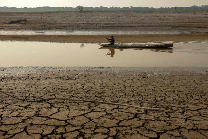
Farmland flooded
Meanwhile, China has bought $32.6 billion worth of manufacturing, agriculture and energy products from the US in the five months from January to May. That is equivalent to 19% of its 2020 goal of $172.7 billion reportedly agreed under the ‘Phase 1’ trade deal signed near the start of the year.
Looking forward, agricultural purchases are expected to accelerate with the US and other countries in coming months because the floods across southern China have ravaged 3.53 million hectares of farmland.
Chinese crushers normally turn to US soybeans around the fourth quarter, after the American soybean harvest starts in September (while sowing of the new crop of Brazilian soybean begins).
With reporting by AFP